|
Cliparts
- I Love My Country Dolls - EUROPE - Page 2 |
|
|
EUROPE
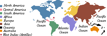 Second
smallest continent and second most populous. Is separated from
Africa by the Mediterranean Sea and the Strait of Gibraltar.
The countries of Europe are: Albania, Andorra, Austria, Belarus,
Belgium, Bosnia and Herzegovina, Bulgaria, Croatia, Czech Republic,
Denmark, Estonia, Finland, France, Germany, Greece, Holland,
Hungary, Ireland, Italy, Iceland, Latvia, Liechtenstein, Lithuania,
Luxembourg, Macedonia, Malta, Moldova, Monaco, Norway, Poland,
Portugal, Romania, Russia (European part), San Marino, Slovenia,
Slovakia, Spain, Sweden, Switzerland, Turkey (European part),
Ukraine, United Kingdom, Vatican City and Yugoslavia (FRY - Federal
Republic of Yugoslavia, formed by the union of the states of
Serbia and Montenegro. The other Yugoslavian Republics, Bosnia,
Croatia, Macedonia and Slovenia, declared their independence
in 1991 and 1992, leaving only Serbia and Montenegro unified).
Choose
your doll and right-click to save it to your hard drive.
Second
smallest continent and second most populous. Is separated from
Africa by the Mediterranean Sea and the Strait of Gibraltar.
The countries of Europe are: Albania, Andorra, Austria, Belarus,
Belgium, Bosnia and Herzegovina, Bulgaria, Croatia, Czech Republic,
Denmark, Estonia, Finland, France, Germany, Greece, Holland,
Hungary, Ireland, Italy, Iceland, Latvia, Liechtenstein, Lithuania,
Luxembourg, Macedonia, Malta, Moldova, Monaco, Norway, Poland,
Portugal, Romania, Russia (European part), San Marino, Slovenia,
Slovakia, Spain, Sweden, Switzerland, Turkey (European part),
Ukraine, United Kingdom, Vatican City and Yugoslavia (FRY - Federal
Republic of Yugoslavia, formed by the union of the states of
Serbia and Montenegro. The other Yugoslavian Republics, Bosnia,
Croatia, Macedonia and Slovenia, declared their independence
in 1991 and 1992, leaving only Serbia and Montenegro unified).
Choose
your doll and right-click to save it to your hard drive. |
 |
LUXEMBOURG |
|
The
Gran-Duchy of Luxembourg, with its 2.586 km2 territory, is the second smallest country in
Europe (Liechtenstein, with 160 km2 is the first). It is bounded by Belgium, Germany
and France. Luxembourg city is its capital. |
|
|

|
|
NETHERLANDS |
|
A constitutional
monarchy of northwestern Europe, the Netherlands, unofficially
known as Holland, is a country with a low and plain territory.
About half of the country's landmass lies below sea level. Together
with Belgium and Luxembourg, The Netherlands forms the Low, or
Benelux, Countries. It is bounded by the North Sea and has borders
with Germany and Belgium. Amsterdam is the capital and the Hague
is the seat of the government. The main cities are Amsterdam,
the Hague and Rotterdam, the main port of the country. |
|
|
 |
NORWAY |
|
Country
in the north of Europe that forms the north-west past of Scandinavia.
Its coastline, extends from the from the North Sea to the Arctic
Ocean. It has a large border with Sweden, and is also bounded
by Finland and Russia. The capital is Oslo. |
|
|
 |
PORTUGAL |
|
Country
in the west of Europe, located in the Atlantic coast of the Iberia
Peninsula. It is bounded by Spain to the north and to the east
and by the Atlantic Ocean to the west. The country was colonized
by Celtic tribes from 500 b.C. onwards and was first known as
Lusitania. Portugal discovered Brazil in 1500 and ruled the country
until 1822. The capital of Portugal is Lisbon. |
|
|
 |
RUSSIA |
|
Russia,
or Russian Federation (Russian Rossiyskaya Federatsiya), is an
independent republic located in eastern Europe and northern Asia
and is the world’s largest country by area. Russia was once
the largest and the most prominent republic of the Union of Soviet
Socialist Republics (USSR, or Soviet Union). In 1991 the USSR
broke apart and Russia became an independent country.
On
the north Russia is bounded by extensions of the Arctic Ocean:
the Barents, Kara, Laptev, East Siberian, and Chukchi seas. On
the east the country is bounded by the Pacific Ocean and several
of its extensions: the Bering Strait (which separates Russia
from Alaska), the Bering Sea, the Sea of Okhotsk, and the Sea
of Japan (East Sea). In the extreme southeast Russia abuts the
northeastern tip of North Korea. On the south it is bounded by
China, Mongolia, Kazakhstan, the Caspian Sea, Azerbaijan, Georgia,
and the Black Sea. On the southwest it is bounded by Ukraine,
and on the west by Belarus, Latvia, Estonia, the Gulf of Finland,
and Finland. In the extreme northwest, Russia is bounded by Norway.
Lithuania and Poland border Kaliningrad Oblast, a Russian exclave
on the Baltic Sea.
Administratively,
Russia includes 21 republics; 6 territories known as krays; 10
national areas called okrugs; 49 regions, or oblasts; 1 autonomous
oblast; and 2 cities with federal status. The capital and largest
city is Moscow. |
|
|
 |
SCOTLAND |
|
Scotland
is one of the four national units that make up the United Kingdom
of Great Britain and Northern Ireland. The other units are England,
Northern Ireland, and Wales. Edinburgh is the capital of Scotland,
and Glasgow is its largest city. Scotland and its offshore islands
comprise the northernmost part of the United Kingdom. |
|
|
 |
SPAIN |
|
Country
that occupies the greatest part of the Iberia Peninsula, in the
south-east of Europe. It is bounded by France along the Pyrinées,
and Portugal. The capital is Madrid. |
|
|
 |
SWEDEN |
|
Country
in the north of Europe that comprises the east part of the Scandinavian
Peninsula, along the Baltic islands of Gotland and Öland.
It is bordered by Norway and Finland. Its coastline is bounded
by the Baltic Sea, the Gulf of Bothnia and the Kattegat Channel.
The north of the country is situated in the interior of the Arctic
Circle. The capital is Stockholm. |
|
|
 |
SWITZERLAND |
|
Country
in central Europe formed by the union of 23 cantons. It is bounded
by France, Germany, Italy and Liechtenstein. It is the highest
country in Europe. The capital is Bern. |
|
|
 |
UNITED KINGDOM |
|
Officially
the United Kingdom of Great Britain and Northern Ireland, the
United Kingdom is a constitutional monarchy in northwestern Europe.
The country comprises the islands of Great Britain, Northern
Ireland and other small islands. England, Scotland and Wales,
are located in the island of Great Britain and Northern Ireland
is located in the island of Ireland. The flag above is the flag
of the United Kingdom, England, Scotland, Wales and Northern
Ireland have different flags.
The
term Great Britain refers only to the island of Great Britain,
which does not include Northern Ireland. United Kingdom, UK,
and Britain are names for the entire nation, although the term
Britain is also used for the island of Great Britain.
The
term England is not properly used for the island of Great Britain,
because England is only one part of the island. British is how
people from England, Scotland and Wales are called, and English
is how people only from England are called. People from Scotland
are Scottish and people from Wales are Welsh.
Great
Britain is the largest island in archipelago, known as the British
Isles. England is the largest and most populous part of the island
of Great Britain. Wales is located on the west and Scotland is
in the north. Northern Ireland is located in the northeast corner
of Ireland, which is the second largest island in Britain. The
capital of the United Kingdom is London. |
|
|
 |
WALES |
|
Wales,
part of the United Kingdom of Great Britain and Northern Ireland,
united politically, legally, and administratively with England
and occupying a broad peninsula on the western side of the island
of Great Britain. Wales also includes the island of Anglesey,
which is separated from the mainland by the narrow Menai Strait.
Wales is bounded on the north by the Irish Sea; on the east by
the English counties of Cheshire, Shropshire, Hereford and Worcester,
and Gloucester; on the south by Bristol Channel; and on the west
by Saint George’s Channel and Cardigan Bay. The maximum
north-south extent of the Welsh mainland is about 220 km (about
137 mi); in an east-west direction the distance varies between
60 and 155 km (36 and 96 mi). The total area of Wales is 20,760
sq km (8,020 sq mi). Cardiff is the capital, principal seaport,
and shipbuilding center. |
|
|
 |
YUGOSLAVIA |
|
Yugoslavia
(FRY - Federal Republic of Yugoslavia, formed by the union of
the states of Serbia and Montenegro. The other Yugoslavian Republics,
Bosnia, Croatia, Macedonia and Slovenia, declared their independence
in 1991 and 1992, leaving only Serbia and Montenegro unified).
It is located in the Balkan Peninsula. Belgrade is its capital. |
|
|
:: PREVIOUS PAGE ::
Nothing
other than the graphics provided for the public may be downloaded.
Absolutely nothing in this site is public domain and may not
be copied.
|
|