|
|
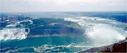
The Niagara
Falls consists of two cataracts: the American Falls and the Canadian
Falls. The American Falls (55 m/182 ft high), on the United States
side, are located between Prospect Point and Luna Island. A small
section of the American Falls located between Luna Island and
Goat Island is also known as Bridal Veil Falls. The Canadian
or Horseshoe Falls (57 m/187 ft high), on the Canadian side of
the river, are located between Goat Island and Table Rock. |
|
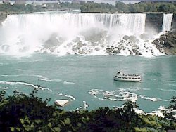
The
American Falls |
|
|
The
crestline of the crescent-shaped Horseshoe Falls, which carries
about nine times more water than the U.S. cataract, is about
670 m (about 2,200 ft) long, and the fairly straight crest of
the American Falls measures 328 m (1,075 ft). |
|
|
|
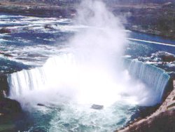
The
Canadian Falls |
On the
picture on the right: my grandpa Lehy, me, my aunt Leila and
my grandma Zilai behind me.
|
Niagara
Falls was formed about 12,000 years ago, when glaciers retreated
north, allowing water from Lake Erie to flow over the Niagara
Escarpment, a ridge that extends in an arc across the northern
Great Lakes region, from Wisconsin to New York. Erosion slowly
pushed the waterfall about 11 km (about 7 mi) upstream, forming
the Niagara Gorge. In 1954 a considerable portion of the American
Falls broke off, creating a large talus, or rock slope, at the
base of the cataract. In order to study ways of preventing further
rockfalls and to remove some of the talus, the American Falls
was successfully “shut off” for several months in 1969
by a dam that was constructed between the U.S. mainland and Goat
Island.
The falls
may be viewed from parks located on either side of the river,
from observation towers, from boats, from Goat Island, and from
the Rainbow Bridge, located a short distance downstream. |
|
|
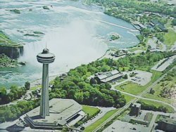
The
Skylon
A tower
with a beautiful view of the falls. Its construction began in
May of 1964 and the tower was opened to the general public on
October 6, 1965. The tower has a total height of 520 feet (160m)
from base to top of flashing beacon. |
|
Here
I am at the entrance of the Skylon tower, back in October 1991. |
|
|
|
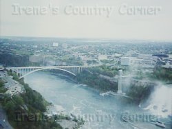
Here
you can see the Rainbow Bridge and a part of the American Falls.
I took this picture from the Skylon. |
|
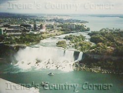
The American
Falls seen from the Skylon and the Bridal Veil Falls on the right.
The Bridal Veil Falls is part of the American Falls catarat. |
|
|
|
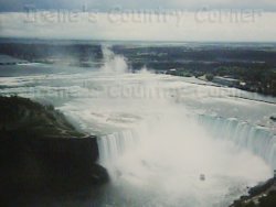
View
of the American Falls and the Canadian Falls to the right. |
|
At the
top of the Skylon tower. |
|
|
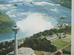
The Skylon
and the Canadian, or Horseshoe Falls. |
|
 ::
Previous
Page
:: ::
Previous
Page
::
|