The
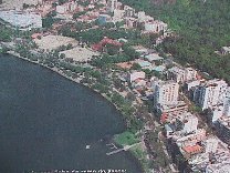
South Zone
 Copacabana,
Flamengo, Botafogo, Ipanema, Leblon, São Conrado, Gávea,
Jardim Botânico, Lagoa and Barra da Tijuca are the main
districts in the South Zone. Each neighborhood was named for
a bay or a beach, such as Flamengo, Botafogo, Copacabana, Ipanema
and Leblon; or a valley, such as Laranjeiras or Gávea.
Copacabana,
Flamengo, Botafogo, Ipanema, Leblon, São Conrado, Gávea,
Jardim Botânico, Lagoa and Barra da Tijuca are the main
districts in the South Zone. Each neighborhood was named for
a bay or a beach, such as Flamengo, Botafogo, Copacabana, Ipanema
and Leblon; or a valley, such as Laranjeiras or Gávea.
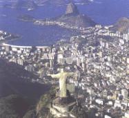
 Rio's
most famous landmarks and beaches are undoubtedly the Copacabana
beach, the Sugar Loaf and the Statue of Christ, located on top
of the Corcovado hill.
Although
Copacabana is the most known, it is not the favorite beach among
most of the "cariocas", as people who are born in Rio
are called. The word "carioca", derives from one of
the Brazilian indigenous people language that literally translating
means: house of the white man ("oca" is their word
for house and "kario' " their word for white man. Kario'
plus oca resulted in "carioca". Rio de Janeiro has
90km of white sand beaches.
Rio's
most famous landmarks and beaches are undoubtedly the Copacabana
beach, the Sugar Loaf and the Statue of Christ, located on top
of the Corcovado hill.
Although
Copacabana is the most known, it is not the favorite beach among
most of the "cariocas", as people who are born in Rio
are called. The word "carioca", derives from one of
the Brazilian indigenous people language that literally translating
means: house of the white man ("oca" is their word
for house and "kario' " their word for white man. Kario'
plus oca resulted in "carioca". Rio de Janeiro has
90km of white sand beaches.
|
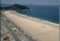
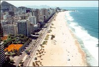
Copacabana,
located in Copacabana and undoubtedly Brazil’s most famous
beach, stretching for around 3,4km. Copacabana is the home of
beach soccer and volleyball, which can be also played during
the night because of light reflectors that were installed on
the beach. |
|
|
|
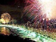
On the
last day of the year, Copacabana beach presents the most famous
and beautiful fireworks show in the whole country. Many tourists
from other cities of Brazil and also a large number of foreign
visitors go to Copacabana to watch this spectacular show. |
|
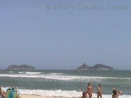
Praia
Vermelha (Red Beach), located at Urca and 245 meters long situated
below hill (picture on the right); Leme, located in Leme and
a continuation of the Copacabana beach, around 1km long;
Arpoador, located
at the beginning of Ipanema and is 800 meters long. |
|
|
|
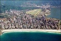
Ipanema,
located at Ipanema. The beach became famous for the song "Girl
from Ipanema" (Garota de Ipanema), by the Brazilian composer
Antônio Carlos Jobim, known as Tom Jobim. The beach spreads
over 2km and is separated from Leblon by the canal at Jardim
de Alah (Alah’s Garden) which links the Rorigo de Freitas
Lagoon (Lagoa Rodrigo de Freitas) to the sea. |
|
Leblon,
located at Leblon. Spreading around 1,3km of sand, the Leblon
beach begins where the canal at Jardim de Alah passes through
going towards the sea. The canal separates the Leblon beach from
Ipanema beach. |
|
São
Conrado, located at Gávea, better known as Praia do Pepino
(Cucumber Beach if translated). Pepino is the landing area for
the city’s hang gliders.
|
|
Barra
da Tijuca, located at Barra da Tijuca. Rio’s longest beach,
stretching over 18km along Av. Sernambetiba and the favorite
among the greates part of the "cariocas" (citizens
from Rio). One of the favorite spot on the beach is the area
around the Barraca do Pepê (Pepê's kioski), a famous
brazilian hang glider who died competing outside Brazil. His
kioski is famous for its delicious natural sandwiches. I can't
go to the beach and come back home without stoping at Pepê
for a sandwich. :o) |
|
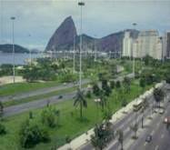
The Parque
do Flamengo (Flamengo Park) occupies an area of 1.200.000 m².
The Monument to Estácio de Sá (founder of the city),
the Monument to World War II, the Museum of Modern Art (MAM)
and the Carmen Miranda Museum can be found along the park area.
It has soccer fields, public basketball courts, paths for jogging,
walking and biking. On weekends the freeway that runs alongside
the park is closed to traffic. The park was built through landfill
and designed by Brazil's master landscape architect Roberto Burle
Marx. |
|
Close
to Flamengo, the Catete Palace (Palácio do Catete), former
official residence of the Brazilian presidents, is today a museum
(Museu da República). It was constructed between 1858
and 1867 by Antônio Clemente Pinto, Baron of Nova Friburgo.
In 1896, during the government of President Prudente de Morais,
it became the presidential residence.
Brazil's
presidents lived in the palace until 1954 (when President Getúlio
Vargas committed suicide in his bedroom). With the transfer of
the capital of Brazil to Brasília, the Palace was transformed
in a museum, which is one of the most interesting in Rio, with
a cultural project that encompasses exhibitions, music, theater,
cinema, video, a book shop and access to over 20.000 books, 7.000
assorted items and 80.000 documents. The museum has a large collection
of French and Brazilian furniture, paintings by Henrique Bernadelli,
Gustavo Dall'Arce, Rodolfo Amoêdo, sculptures from the
19th and 20th centuries, presidential memorabilia etc.
Located
at Botafogo, the "Museu do Índio" is a museum
dedicated to native Brazilians, their art and culture. Pottery,
wood, straw and feather are some of the materials used in creative
ways by tribes from all parts of Brazil. The museum takes an
active role in promoting a better understanding of the native
Brazilian culture.
A group
of natives were brought to the museum in order to build a Uné,
a large Indian home, 5 meters tall and 15 meters long. Inside
were installed hammocks, cooking pans, flutes and straw skirts
so that visitors can learn how natives decorate their homes.
There is genuine hand craft for sale in the museum store.
|
|
The Rodrigo
de Freitas Lagoon occupies an area of 2.4 million square meters
of water surface. The 7.5 km long path around the lagoon is used
by people for biking, walking or roller skating. It is the most
frequented open-air area in Rio, receiving around 60.000 people
every weekend. |
Two important
clubs in Rio are located in the lagoon: the "Clube Naval"
and the "Clube Caiçaras". The lagoon is surrounded
by the districts Ipanema, Leblon, Jardim Botânico and Gávea.
It is also connected to the North Zone by the Rebouças
tunnel, constructed at the base of the Corcovado hill.
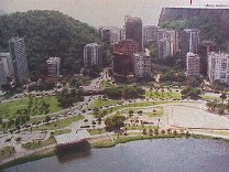
Below
you can see parts of the lagoon. The residential area constructed
around it is made of beautiful tall buildings and the apartments
in this area are very expensive. On the right you can see a small
part of the Botanical Garden, a beautiful 340-acre garden built
in 1808.
|
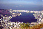
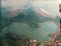
The Rodrigo
de Freitas Lagoon is also known as the "heart of Rio"
for it is shaped like a heart as you can see on this picture.
In the lower part of the picture, you can see the Clube Naval
on the left and the Caiçaras Club on the right, inside
the lagoon. In the upper part, you can see the Copacabana beach
on the right and the Sugar Loaf a little to the left. I scanned
this picture from a newspaper, it's not so good, but I hope you
can see it. |
|
|
|
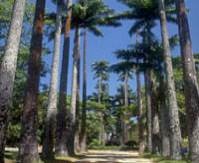
The Botanical
Garden (Jardim Botânico), founded by Dom João VI
in 1808, is one of Rio's most famous natural attractions. The
340-acre garden has over 5.500 species of trees and bushes, including
900 varieties of palm trees and over 140 species of birds.
It is
famous for its beautiful and soaring Imperial Palms planted in
1842, the tallest ones in the world. |
It is
the home of a large variety of plants, including aquatic and
carnivore and different types of orchids that can be seen in
the interior of a green house located in the park. It is located
in the district that receives the same name.
|
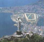
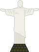
Standing
at the top of the Corcovado mountain, stands the world famous
statue of Christ, measuring 38 meters (98 feet high) with a 26
foot pedestal containing a chapel that can hold 150 people.
Known
as Christ the Redeemer (Cristo Redentor), the statue was brought
to the top of the hill in 1931. It was elaborated by the Brazilian
architect Heitor da Silva Costa and sculpted by the French Paul
Landwilk. |
|
|
|
In 1993
a new illumination was brought to the statue and now it can be
better viewed from the most varied and distant parts of the city.
The Corcovado mountain is 704 meters high (2,330 feet above sea
level) and it provides the most beautiful view of the city from
its top. From that privileged position we can see a breathtaking
view of the Guanabara Bay and the Sugar Loaf. It can be accessed
by car by the road through the Parque Nacional da Tijuca or by
the funicular located in the Estrada de Ferro Corcovado leaving
from the Cosme Velho station. The ride to the top takes 16 minutes. |
|
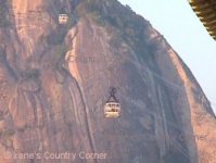
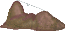
The Sugar
Loaf, undoubtedely the most famous natural symbol of Rio de Janeiro,
is located in the Guanabara Bay and the access to the top is
made by cable car. The journey to the top is divided in two parts.
There is a cable car, which rises 705 feet above the bay, departing
from the station at Praia Vermelha to the top of the firslt hill,
called Morro da Urca (Urca Hill), and another one that goes to
the top of the second (almost 400 meters high - 1,300 feet high)
which is the Sugar Loaf itself, called Pão-de-Açúcar
in Portuguese. Each cable car ride lasts about 3 minutes. |
|
The Sugar
Loaf is a group of three hills : The Morro da Urca (Urca hill
- Urca is the name of the neighborhood where it's located), the
Pão-de-Açúcar (Sugar Loaf) and another one
called Morro Cara de Cão (Dog Face hill, if literally
translating). On the top of the Morro da Urca there is an area
larger than 3.500 m² with restaurants, shops, theater, recreation
places for children etc. There is also a small area where the
visitants can see some kinds of plants and small birds from Brazil.
<<
Back <<
|
Brazilian
Menu
|
|
|