|
Cliparts
- I Love My Country Dolls - SOUTH AMERICA |
|
|
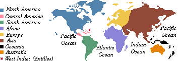
SOUTH AMERICA
 Fourth
largest continent of the Earth (after Asia, Africa and North
America). Its main part is located in the south hemisphere. Between
1816 and 1825 the greatest part of the Spanish South America
became independent and was divided in countries: Venezuela, Colombia,
Ecuador, Peru, Bolivia, Chile, Argentina, Uruguay and Paraguay.
Brazil
was not part of the Spanish South America and became independent
from Portugal in 1822. The English Guyana became the independent
Guyana in 1966 and Suriname became independent from the Netherlands
in 1975. The French Guyana, located on the north of Brazil is
still a department of France.
The
continent is formed by: Argentina, Bolivia, Brazil, Chile, Colombia,
Ecuador, French Guiana (a department of France), Guyana (former
dependency of the United Kingdom), Paraguay, Peru, Suriname (former
dependency of the Netherlands), Uruguay and Venezuela.
Choose
your doll and right-click to save it to your hard drive.
 |
 |
ARGENTINA |
 |
Second
largest country in South America. It is bounded by Chile, Bolivia,
Paraguay, Brazil, Uruguay and the Atlantic Ocean. Buenos Aires
is its capital. |
|
|

 |
BOLIVIA |
 |
Country
located inland of South America. Borders Brazil, Paraguay, Argentina,
Chile and Peru. Its capital is La Paz. |
|
|

 |
BRASIL |
 |
Largest
country in South America. Borders all countries in the continent
with the exception of Chile and Ecuador. It is bounded on the
east by the Atlantic Ocean and its coast line is located mainly
between the Equator line and the Tropic of Capricorn.
It
is the only country is South America that was not part of the
Spanish South America. It was discovered by a Portuguese navigator
in 1500 and achieved its independency from Portugal in 1822.
It was first a Kingdom under the name of United Kingdom or Portugal,
Brazil and Algarves, it became an Empire (Empire of Brazil) after
the independence in 1822 and was proclaimed a Republic in 1889,
and received the official name of Federal Republic of Brazil.
Its
capital is Brasília and the language spoken is Portuguese.
Contrary to what many people think, Spanish is not spoken anywhere
in Brazil. |
|
|

 |
CHILE |
 |
Narrow
and long country located on the west coast of South America.
Borders Argentina, Bolivia and Peru. It is bounded by the Pacific
Ocean. Santiago is its capital. |
|
|

 |
COLOMBIA |
 |
It
is the only country in South America that is bounded by both
Atlantic and Pacific oceans. Borders Ecuador, Peru, Brazil, Venezuela
and Panama. Bogota is its capital. |
|
|

 |
PARAGUAY |
 |
Paraguay,
a country in South America, was a Spanish colony before it gained
independence in 1811. In 1865 Paraguay’s president dragged
the country into a disastrous war with its more powerful neighbors,
Argentina, Brazil, and Uruguay. Half of Paraguay’s people
died before the fierce war ended in 1879. Paraguay also lost
a fourth of its territory. Asunción, Paraguay’s capital
and largest city, is the chief port on the Paraguay River. |
|
|

 |
PERU |
 |
Country
bounded on the north by Ecuador and Colombia, on the east by
Brazil and Bolivia, on the south by Chile and on the west by
the Pacific Ocean. Lima is its capital. |
|
|

 |
URUGUAY |
 |
Country
located south-east of the central region of South America. It
is bounded by Argentina, Brazil and the Atlantic Ocean. Montevideo
is its capital. |
|
|

 |
VENEZUELA |
 |
Venezuela,
officially Bolivarian Republic of Venezuela, republic in South
America. Venezuela sits at the northern edge of the Andes Mountains,
which dominate the northwestern portion of the country. To the
east lie the plain of the Orinoco River and the rugged inland
region of the Guiana Highlands. The coastline of Venezuela is
about 2,800 km (about 1,700 mi) long and has numerous recesses,
of which the gulfs of Venezuela and Paria are notable. Except
in the west, which has expanses of low and occasionally marshy
land, the coast is generally narrow and steep. Of the 72 coastal
islands that belong to Venezuela, Margarita is the largest and
most important.
Venezuela
is divided into 23 states; federal dependencies, which comprise
72 islands in the Caribbean; and the Federal District, site of
Caracas, the national capital. |
|
|
 Nothing
other than the graphics provided for the public may be downloaded.
Absolutely nothing in this site is public domain and may not
be copied.
|
|